Canalblog
Suivre ce blog Administration + Créer mon blog

Randonner avec Franck

3 juin 2012

A nice Hike around Adelboden with a cool view on Plaine Morte Glacier

on that sunny day of October 2011, I made up my mind to discover a bit the Alps around Bern...

On that day I have no map, just a car and my backpack, so direction Adelboden... Why ? Easy. As a ski fan you know Adelboden. A highlight of the Worldcup season. My thinking is easy, Adelboden means mountains, so there should be something to see over there and it is reachable within 2 hours from Basel !

I park my car at the footh of Adelboden at Oey (1265m).  And I see a sign direction Hahnenmoos. It is a part of the Via Alpina, so I cannot be wrong.

iPhone oct11 - mai11 002

Then it goes up on a very nice crest to Hahnenmoospass... We see here the final destination with the Ammerspitz summit on the left side of the picture.

iPhone oct11 - mai11 003

From Hahnenmoospass the trail goes left and catches an alpine trail with no specific difficulties but a secure walk is necessary and hands can be helpful.

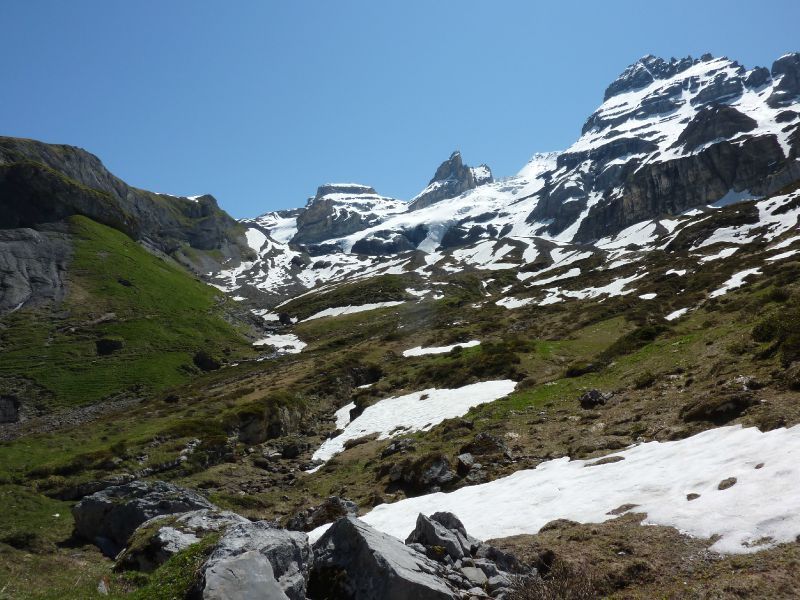
In october some remainings of the snow are still present :

iPhone oct11 - mai11 004

Ariving at Ammertenspitz summit the view is great over Plaine Morte.

iPhone oct11 - mai11 007

On the way down to Engstligenalp, I anyway take the time for a rest... Read some pages of my book in the sunny day. And also looking some people playing golf at 2000 meters high!!

Then it is time to head down the mountain to Engstligenwasserfälle. On these days in end October, it is very slippy as parts of the trails are frozen... but the view on the water fall is just great :

iPhone oct11 - mai11 013

I finish that trek completely exhausted as the way arrives below to where I parked my car and the 20 minutes up to reach the parkplace are a nightmare. But the beer is well deserved on that day.


Difficulty : T3 (demanding trek) - careful on the alpine way to Ammerspitz (600m gas below...)

Up : 1450m

Down : 1450

Timing : 6 hours with no stops.

Trail description : Adelboden - Eselmoos - Hahnenmoospass - Ammertenspitz - Ammertenpass - Engstigenalp - Engstligenwasserfälle - Adelboden


Publicité
Publicité
3 juin 2012

Une belle randonnée à Kandersteg - 2 juin 2012

this second of june, I headed towards Kandersteg, with the goal to cross between Kandersteg and Frutingen. After 2 hours train trip, unfortunately my trail is closed because of some avalanches that broke part of the trails...

So next decision direction the other valley to Oeschienensee. And then lets see !

Up to Oschienensee :

P1020203

So nice... I move up direction Oberbärgli and Blüemilisalphütte... First remaining of snows are to be seen around 2000m.

P1020208

I am a bit behind schedule if I want to be back in Basel tonight. I decide to stop 400 meters under the hut (already 1300 meters up anyway...). and as an alternative I take another way from Oberbärgli (1978m) on the right of the river to make a nice round above the lake. And look at this view... No need to go to Canada, we have everything in Europe :

P1020223

Finally on the way down, it is pretty hot, and I decide to stop under a natural shower...

P1020217

After a bit more of 7 hours of efforts it is "Panach" o'clock in Kandersteg, a very nice mountain village of the Bern Alps.

Reference of the Trek : Kandersteg - Oberbärgli - Hohtürli - Oberbärgli - Oeschinenensee - Kandersteg

Up : 1300m

Down : 1300m

Total hiking time without stops : around 6 hours

Publicité
Publicité
Randonner avec Franck
  • Quelques images et descriptions de randonnées que je peux faire seul ou avec des enfants. Aussi la possibilité d'échanger de belles photos ou idées autour de l'activité trekking... La description des trekks est en anglais, mais le français es t bienvenu
  • Accueil du blog
  • Créer un blog avec CanalBlog
Publicité
Archives
Publicité